

County Commissioners

Maps & GIS

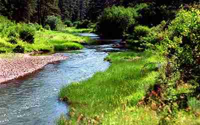
Visit Harney County
Follow this link to explore all that Harney County has to offer.

Harney County Budget
Follow this link to view the current Harney County Budget.

Employment Opportunities

Online Payments

Boards & Committees

Sheriff’s Office
Follow this link to view information on the Harney County Sheriff’s Office and Community Corrections.

Planning Department

Records & Research

Clerk & Recorder

Economic Development
Follow this link to access the HCED site where they stand ready to assist with your business development needs.
Latest News & Events
Work Session
Join us on Zoom or in person for a work session. Meeting will be held at the Harney County Courthouse. * (https://us06web.zoom.us/j/4344793664?omn=86263412008) * Phone: (669) 444-9171, Meeting ID: 434 […]
Harney County Court Meeting
Harney County Courthouse 450 N Buena Vista Ave, Burns, OR, United StatesCitizens of Harney County encouraged to participate!
Harney County Budget Committee Meeting if needed
Harney County Courthouse 450 N Buena Vista Ave, Burns, OR, United StatesNOTICE OF HARNEY COUNTY BUDGET COMMITTEE MEETING Public meetings of the Budget Committee of Harney County, State of Oregon, to discuss the budget for the fiscal year July 1, 2024 […]
Natural Resource Advisory Committee
Basement Meeting Room of the CourthouseThe Natural Resource Advisory Committee meets monthly on the first Tuesday from 6-7:30PM in the basement meeting room of the Harney County Courthouse.
Eastern Oregon Counties Association (EOCA)
You are welcome to attend the EOCA meeting, May 13th, 2024 from 9 - 11 am. Follow the link to attend: https://us02web.zoom.us/j/81389991120?pwd=OXBTTkI1ZjlJelVrTnZDTGpsSzlaQT09

Harney County Court Meeting
Harney County Courthouse 450 N Buena Vista Ave, Burns, OR, United StatesThe Harney County Court meets every 1st and 3rd Wednesday of the month starting at 9:30 AM (9:30 to 10:00 paying bills, 10 to Noon Court Session, Noon to 1PM […]
Harney County Budget Committee
This post has information regarding the 2024-2025 Harney County Budget Committee and its meeting schedule.
Southeast Oregon Broadband Action Team
Southeast Oregon Broadband Action Team (SEOBAT) Harney County has begun the foundational work to bring reliable, affordable, high speed internet to its remote communities.
Harney County Library Advisory Board
Harney County Library Advisory Board As advocates for the library, the responsibilities of the Advisory Board are as follows:• Propose rules and policies for the governance of the library for approval to the County Court.• Prepare and submit an annual budget request...
Harney County Local Public Safety Coordinating Council
The Harney County LPSCC is a collaborative effort created as a result of Senate Bill 1145 that brings together many community partners to address local criminal justice policy and resources. Over the years, Harney LPSCC has met to address and coordinate local issues around public safety.

Harney County Local Community Health Partnership
The Harney County LCHP works to develop productive local partnerships with community-based organizations, healthcare systems (medical, behavioral, and oral health), local governments, OHP members, Tribes, and other local entities who address Social Determinants of Health and Health Equity in order to facilitate locally driven health system transformation.
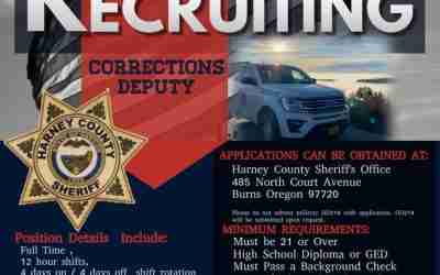
Corrections Deputy
Harney County Sheriff’s Office is currently recruiting for a Corrections Deputy. Follow the link below to learn more information.

911 Dispatch Job Opening
The Harney County Sheriff’s Office is recruiting for a 911 Dispatch position. Follow the link below for more information.

Citizen Action Center
View Current Inmates
This link accesses the list of inmates currently in custody in the Harney County Corrections facility. It is updated once per day.
Subscribe to Newsletter
Use this link to subscribe to receive Harney County Newsletter with current topics and happenings.
Employment Opportunities
Find the details about current job openings with the Harney County government.
Elected Officials
Coming Soon: Learn more about your elected officials and find contact information to engage with them.
Interactive Mapping
Explore Harney County’s GIS Map Hub using this link.
Floodplain Information
Learn more about recent updates to Harney County’s floodplain map.
Online File Center
Notices
Public notices can be found here.